Here are a few section of biking maps depicting North Kanata

From MapArt Ontario paper map published in 1999
This map is pretty decent given that very large part of the Kanata we know today did not exist at the time of printing. There are parts of the bike infrastructure missing even though they existed long before the map was made. For example, a path through Beaverbrook Park connecting Parkway and Campeau adjacent to Oakes Wood is missing.
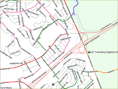
This is a section of on-line City of Ottawa on-line map published in 2006
The online version of this map is difficult to navigate. There is an “emap” version, but it requires an install. I don’t remember if I ever installed it, but if I did I don’t remember being impressed. Again, despite Beaverbrook now changing for at least a decade if not four, this map shows different paths than the above one. The path between Parkway and Campeau is present (yay!) but the paths on Leacock and Parkway surrounding Alice Woods (name not on the map) are incorrectly drawn. Also, the paths next to the Stephen Leacock elementary school are missing as are others, notably the link between Beaverbrook and Kanata Lakes (Leacock to Knudson by Tiffany Crescent). This map, besides being on-line and free, is definitely inferior to the printed version.

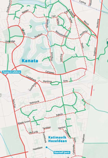
Map from the Ottawa Cycling Plan document published in 2008
As is expected from a decent planning document, this has all the paths I can think of, even the little paths surrounding public buildings like the library, high school and daycare. An interesting omission on this map is the link between Beaverbrook and Kanata Lakes present on the on-line city map. I believe this link is owned by the City but the golf course people paint “Private” on it every year and every year it gets painted over in black paint (by the City or a citizen, I don’t know). Another thing noticeable about this map is that it has Castlefrank south of the highway marked as a “shared route” which I have never heard of before but I suppose it means that the road is extra vide to allow for cyclists, even though there are no painted lanes. I like this because Castlefrank is a good connection to get to Hazeldean from the highway overpass.
In any case, this map is the most complete map despite not being intended for “tourist” use.
Recently published (privately?) Capital region cycling map. It is not advertised from the city website, but there is City logo on the map itself as well as NCC, Gatineau and Bixi logos
I like the look and feel of this map even though it sacrifices street names of all but the major thoroughfares for the tidy look. I love the suggested routes in dotted red. In content, this map has more paths than the 2006 on-line map, but also carries mistakes present in that version (messed up path north of Parkway). There are also discrepancies with the planning document map, notably in the Village Green (south of Campeau) area, though they might be due to area being built up since 2008. Minor paths, such as ones leading to the library, high school and daycare are missing, but that might be by choice. It is interesting that the section of Castlefrank, marked on the City planning map as shared use, is not marked on this map at all, not even as a suggested route even though this would be my choice trajectory to get to Hazeldean.
Overall, this map is a definite improvement over the 2006 version but I wish that they had used the city planning map rather than whatever they used to determine where the paths are. Suggested routes are a step in the right direction, but you have keep in mind that they are someone else’s choice and might not reflect your own preferences.

Screen capture of Google Maps with cycling directions
Then there is the Google, because, frankly, that is the map that I, if not most people, am most likely to use. It is in Beta version which explains the bizarre choices of which paths are marked. There are at least a couple of paths noted here that are not in any other maps. These paths exist in real life but I am guessing they are too recent for the other maps. I’ve submitted a request to add the path next to Beaverbrook Park to the map so I am waiting to see if there will be any reply. I suspect that this map will be much better once it is out of Beta. Until then, meh!
The drag-and-drop option in Google maps makes it really easy to find the distance of a cycling trip. It is really frustrating, however, when a path is not present on the map.
I believe that the http://www.capitalcyclingmap.ca map is the official 2011/2012 cycling map. I can’t wait to get a paper copy.